GeoLing
- 1:
 About GeoLing.
 - 2: Imprint.
What is GeoLing and what does it do?
In short, GeoLing is a handy tool for performing statistical analyses on spatial data: You can use data from dialect surveys, transform them into smoothed maps (via density estimation), detect structures that run through the data and find groups of maps that share spatial features.
We developed this program with linguistic applications in mind, but that should not stop you from using it for any kind of spatially conditioned data.
Acknowledgements
GeoLing was written as a part of the project New Dialectometry Using Methods of Stochastic Image Analysis ( project homepage), financed by the Deutsche Forschungsgemeinschaft (DFG) between 2008 and 2014. All the work has been carried out by people associated with three institutions:
- Institute of Stochastics (Ulm University)
- Lehrstuhl für Deutsche Sprachwissenschaft (University of Augsburg)
- Fachbereich Germanistik (University of Salzburg)
Download and installation
The software is written in Java – as Java runs on multiple platforms, there is one version for all users. Please make sure that the Java version running on your machine is up to date; updates are obtainable at www.java.com. The latest version of GeoLing and the accompanying guide are always available on this site.
Download:
 GeoLing 1.0 (ZIP file, 150 MB, published 2014-09-22, user guide)
- GeoLing on GitHub (source code)
Originally, the software was developed for and tested on the data of the Sprachatlas von Bayerisch-Schwaben (SBS). The corresponding database (that served as the basis for most examples in the guide as well) is supplied for demonstration purposes.
GeoLing is ready to use after unzipping a single file; no installation is required. The guide includes a detailed section on how to import your own data sets.
License and terms of usage
This software is licensed under the GNU General Public License v3.0 (published on 29 June 2007). The full text of GPL 3 is available at https://www.gnu.org/licenses/gpl-3.0.
Although we took reasonable precautions and conducted extensive testing, we would like to stress that the software comes without any warranty or guarantee.
References
The following articles describe the approaches implemented in GeoLing:
Intensity estimation and area-class-maps:
- J. Rumpf, S. Pickl, S. Elspaß, W. König and V. Schmidt, Structural analysis of dialect maps using methods from spatial statistics (Preprint). Zeitschrift für Dialektologie und Linguistik 76 (2009), 280–308.
- S. Pickl and J. Rumpf, Automatische Strukturanalyse von Sprachkarten. Ein neues statistisches Verfahren (Preprint). In: E. Glaser, J.E. Schmidt and N. Frey (eds.): Dynamik des Dialekts - Wandel und Variation. Akten des 3. Kongresses der Internationalen Gesellschaft für Dialektologie des Deutschen (IGDD). (Zeitschrift für Dialektologie und Linguistik, Beihefte, 144.) Steiner, Stuttgart (2011), 267–285.
- S. Pickl and J. Rumpf, Dialectometric Concepts of Space: Towards a Variant-Based Dialectometry (Preprint). In: S. Hansen, C. Schwarz, P. Stoeckle and T. Streck (eds.): Dialectological and folk dialectological concepts of space. Walter de Gruyter, Berlin (2012), 199–214.
Linguistic distances in intensity estimation:
- S. Pickl, A. Spettl, S. Pröll, S. Elspaß, W. König and V. Schmidt, Linguistic distances in dialectometric intensity estimation (Preprint). Journal of Linguistic Geography 2 (2014), 25–40.
Factor analysis:
- S. Pröll, S. Pickl and A. Spettl, Latente Strukturen in geolinguistischen Korpora (Preprint). In: M. Elmentaler, M. Hundt and J.E. Schmidt (eds.): Deutsche Dialekte. Konzepte, Probleme, Handlungsfelder. Akten des 4. Kongresses der Internationalen Gesellschaft für Dialektologie des Deutschen (IGDD) in Kiel. (Zeitschrift für Dialektologie und Linguistik, Beihefte, 158.) Steiner, Stuttgart (2015), 247–258.
Clustering of maps:
- J. Rumpf, S. Pickl, S. Elspaß, W. König and V. Schmidt, Quantification and statistical analysis of structural similarities in dialectological area-class maps (Preprint). Dialectologia et Geolinguistica 18 (2010), 73–98.
- D. Meschenmoser and S. Pröll, Using fuzzy clustering to reveal recurring spatial patterns in corpora of dialect maps (Preprint). International Journal of Corpus Linguistics 17/2 (2012), 176–197.
Contact
Project management:
- Prof. Dr. Werner KönigLehrstuhl für Deutsche Sprachwissenschaft, University of Augsburg
- Prof. Dr. Stephan ElspaßFachbereich Germanistik, University of Salzburg
- Prof. Dr. Volker SchmidtInstitute of Stochastics, Ulm University
- Prof. Dr. Evgeny SpodarevInstitute of Stochastics, Ulm University
Substantive and technical issues:
- Dr. Simon PröllInstitut für Deutsche Philologie, Ludwig-Maximilians-Universität München
- Dr. Simon PicklFachbereich Germanistik, University of Salzburg
- Dr. Aaron SpettlInstitute of Stochastics, Ulm University
News
Presentations of GeoLing:
- Methods in Dialectology XV, 9:30-10:00 on August 15th, 2014 (Groningen, Netherlands): Bottom-up dialectometry using the GeoLing Package (Abstract, Slides)
- 18. Arbeitstagung zur alemannischen Dialektologie 2014, 14:50-15:10 on October 9th, 2014 (Tübingen, Germany), Bottom‐up‐Dialektometrie mit dem Softwarepaket GeoLing. Sprachgeografische Strukturen im alemannisch‐bairischen Grenzbereich (Abstract, Vortragsfolien)
Applications of GeoLing:
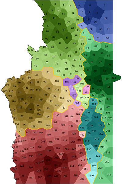
- Sprachatlas der deutschen Schweiz (SDS) - digitized dialect maps: Interpolated surface maps generated with kernel density estimation
Screenshots
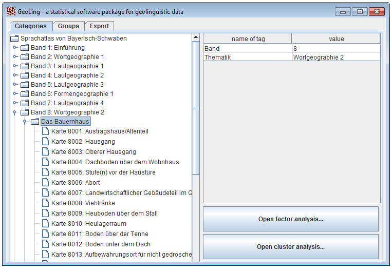 |
 |